A Visit to Blackwood National Park
I haven’t been to this park yet – nor have I finished writing this section
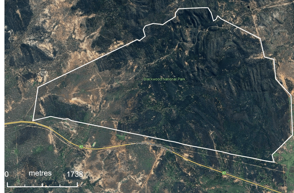
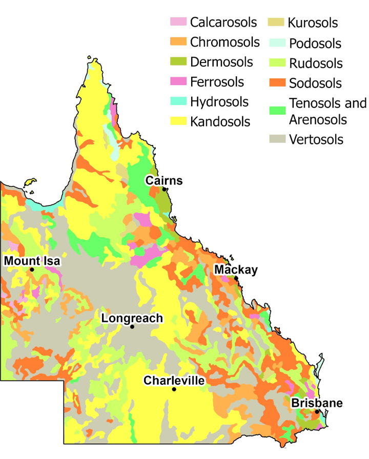
Blackwood National Park is situated alongside the Gregory Development Road (A7, Great Inland Way) ca 180 km south of Charters Towers or 15 km north of Belyando Crossing (Fig 1).

of the Brigalow Belt North Biogeographic Region (red). Image QPWS 2011.
Once part of Mount Hope Station, Blackwood was declared a National Park in 1991 with a role to conserve plant and animal communities in the Brigalow Belt North Biogeographic Region (Fig 1). The Blackwood National Park Management Plan 2011 was extended in 2023 in line with the Queensland Nature Conservation Act 1992 (s120G). Park land is included in an area subject to a native title claim by the Jangga People (QC98/010).
The Park circumscribes 1,648 ha (16.5 km2) of hills and gorges surrounded by undulating sandy clays and small areas of black soil plains that are not otherwise represented in the biogeographic region (Fig 1). Blackwood also contains exposed laterites with distinctive hard pans (QPWS 2011). The landscape has been extensively cleared to the south of the Park and clearing for cropping and improved pastures is increasing to the north. Other protected areas close to Blackwood include Nairana National Park, Nairana National Park (Recovery), Wilandsprey Conservation Park and Moorinya National Park.
Notes on blackwood (A. agyrodendron) and brigalow (A. harpophylla)
The Park derives its name from Acacia argyrodendron, a species colloquially known as blackwood, Belyandro blackwood or black gidyea (QPWS 2011). Some websites incorrectly state that the Park is named after Acacia melanoxylon (also called blackwood).
Acacia agyrodendron grows mostly in dark cracking clays and is native to central Queensland across the Great Divide from the Torrens Creek area east to the Isaac River basin. It is common in the Cape, Suttor and Belyando River basins (Fig 2). On the southern and eastern edges of its range it commonly grows alongside A. harpophylla (Blackwood National Park Management Plan 2011).
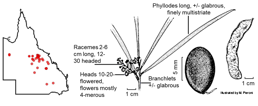
Acacia argyrodendron is similar in general appearance to A. harpophylla, which has larger flower-heads, shorter racemes and subterete, longitudinally ribbed pods (Fig 3). Both species share the mainly tetramerous (4) flower character, flower structure and morphology of the soft seeds.
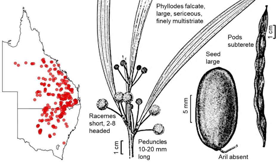
Acacia agyrodendron gives its name to the National Park but, because of the extent of landscape that it inhabits, A. harpophylla gives its name to the woodlands and open forests that dominate the Park, namely brigalow.
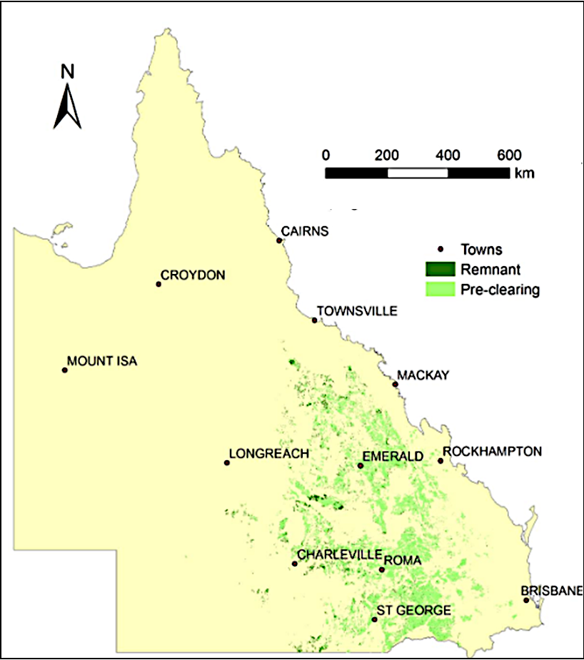
Brigalow assemblages occur over a large area of eastern Australia, often on acidic and salty clay soils (Fig 3). In pre-European times, the range extended from south of Narrabri in New South Wales, to Charters Towers in north central Queensland (Fig 4). Much has been cleared.
The assemblages occurred where rainfall averaged between 500 to 750 mm per annum, with most falling in summer, albeit the amount and seasonality was very variable. In higher rainfall areas brigalow formed open forests or merged with dry rainforests (50 – 80% canopy cover), whereas in drier areas woodlands formed (20 – 50% canopy cover).
Acacia harpophylla is unusual among wattles in that suckering from lateral roots is the main means of reproduction i.e. reproduction is principally vegetative rather than sexual. Regeneration from suckers can be retarded by blade-ploughing which cuts lateral roots. Seed production is not only rare but seeds have no dormancy period and remain viable in the soil for less than a year.
Brigalow is reasonably fire-sensitive. Hot fires inhibit growth and re-establishment, killing mature trees and suckers. Suckering is also susceptible to frequent smaller fires, such as those that occur under well-grassed conditions. Reforestation can be compatible with cattle, as long as grazing pressure is held at low to moderate levels, fires are restricted, and there are sufficient periods where grazing is stopped to allow new trees to establish.
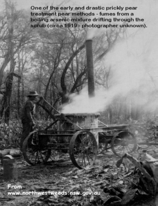
Brigalow and prickly pear
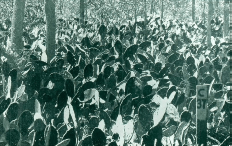
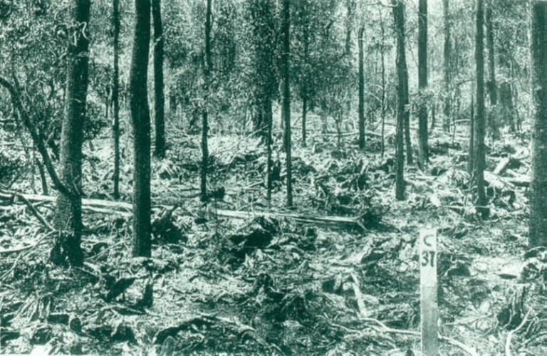
It was in the A. harpohylla brigalow belt that infestations of prickly pear cactus (Opuntia species) were greatest during the 1920s and 1930s (Fig 5). By 1926, Opuntia covered ca 24.3 million ha, an area that was increasing by over 1 million ha per annum. Australia essentially cornered the world supply of arsenic pentoxide for prickly pear control!
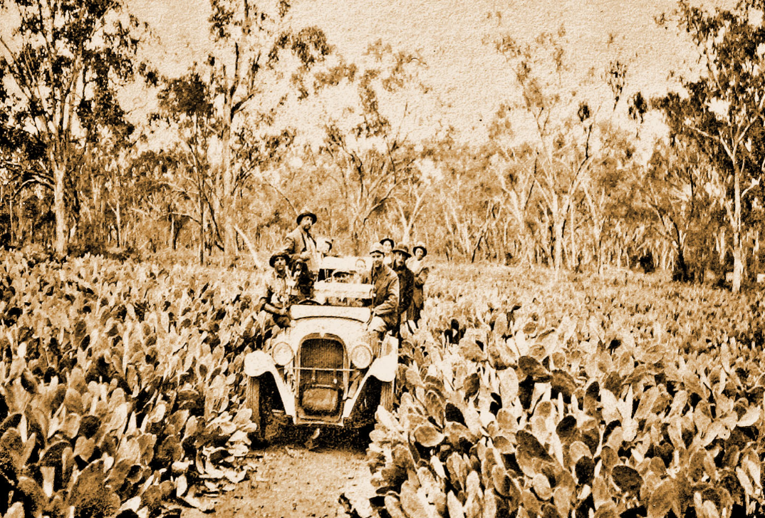
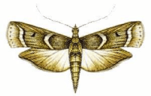
Collected in Argentina in 1925 by A Dodd, the moth Cactoblastis cactorum was introduced in 1926 as a biological control agent for Opuntia (Fig 6). By 1933 ca 80 % of the Opuntia infestation in Queensland was eradicated (National Museum of Australia 1925).

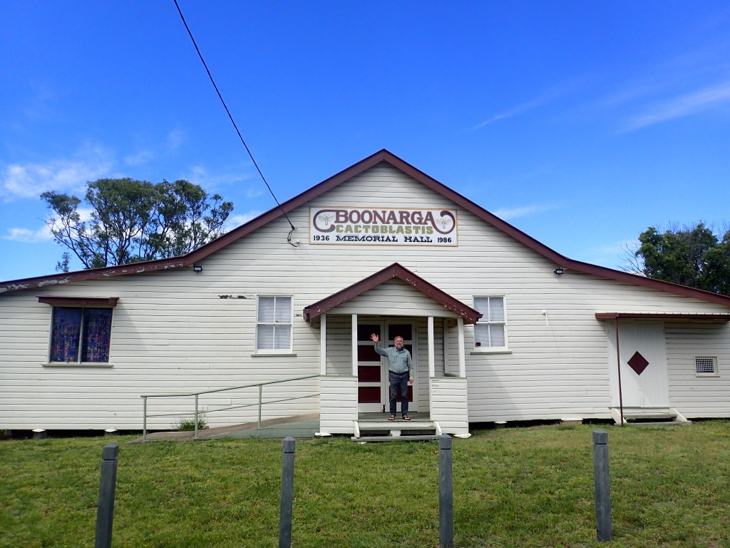
In 1936, the grateful township of Boonarga, which lies on the Warrego Highway between Brigalow and Chinchilla, erected a memorial hall to commemmorate the role of Cactoblastis in controlling Opuntia (Fig 7). Occasional Opuntia still grow alongside the Warrego Highway and the Gregory Development Road.
Park facilities
In Blackwood National Park is a carpark, bicycle track and walking tracks (Fig 8). Driving and camping in the Park are not permitted as the landscape is considered vulnerable to erosion. To this end, the old campground was removed and vehicle tracks were closed. There are no toilets and there is no water supply. Fires are not permitted. The nearest campsite is at Belyando Crossing, ca 15 km distant.
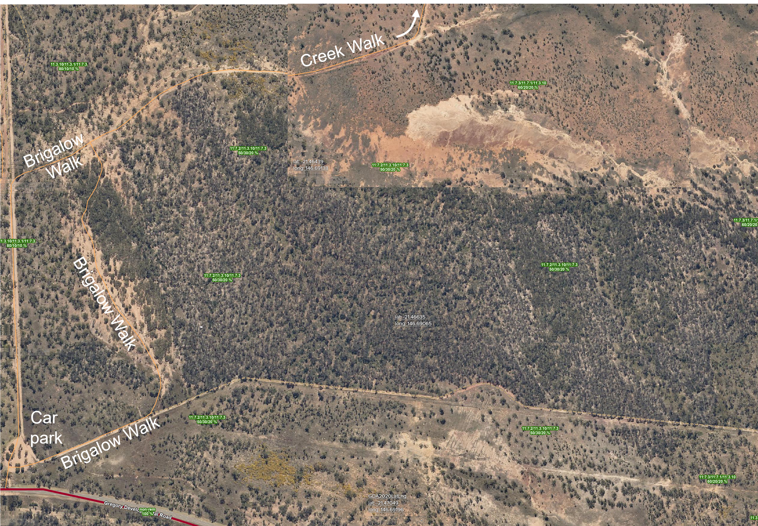
The Brigalow Circuit walk is a 1 km return track, rated as Grade 3 (gentle), that requires ca 45 mins walking time (Fig 8). One walks from the car park through brigalow and lancewood (A. shirleyi) scrub and past small seasonal wetlands.
The Creek Walk, rated as Grade 4, is a 6 km return walk that requires ca 2.5 h. From the car park, one follows this level track for 2.4 km past small seasonal wetlands to the creek, which has a dry bed for most of the year. If one turns right and walks along the creek for 600 m one will find a series of rock holes.
The Park Boundary Ride, graded Intermediate, is a 17 km circuit that requires about ca 5 h by bicycle. Access is via a turnstile at the car park. The track follows the Blackwood National Park firebreak around the boundary (Fig 8). Caution is required on steep and very rocky sections of the track, and conditions are boggy after rain.
Geology, soils and landforms
According to Willmott (2006), Blackwood and Nairana National Park are on low ridges of deeply weathered, steeply-inclined metasediments of the Drummond Basin (Fig 9). The uppermost surface is commonly more recent gravelly sediments.
The upper sediments, soils and landforms of the park include pebbly quartz sandstones with mudstones dating from the Carboniferous. These landforms were created by an ancient river system flowing north from the Springsure area. Tertiary sandstones (which often contain clay and laterite) and Quaternary silts, sands and gravels (including black earths) have been deposited widely throughout the area (QPWS 2011).
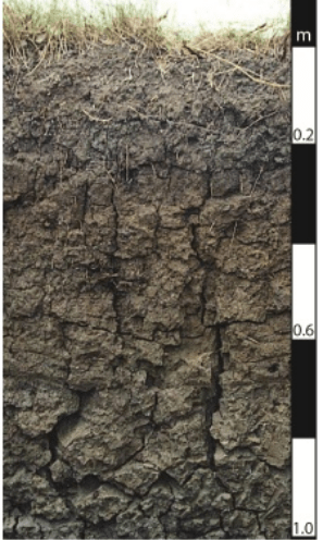
Blackwood’s cracking clays are vertosols, one of Queenslands dominant soil types (Fig 10). These black, brown or sometimes grey soils contract and crack open when dry, often forming pillow-shaped structures called gilgai. The forces associated with soil shrinkage are sufficient to break tree roots such that cracking clays are commonly associated with tree-sparse grasslands, e.g. Mitchell Grass Downs and the Darling Downs. Nevertheless, the soils are fertile and exhibit large water-holding capacities.
Biodiversity of Blackwood National Park
Seventeen regional ecosystems are listed for the Park (Table 1, see also annotations in green on Fig 8). Surprisingly, the Qld Government WildNet web-page lists only xxx plant and animal species (clearly an undercount). About 73 species of birds are documented, only 3 mammals (no bats!), 0 reptiles and amphibians, and X species of plants. I have yet to find any lists of invertebrates.
Table 1 Regional ecosystems identified in Fig 8 and in QPWS (2011)
| Vegetation code | Description of regional ecosystem | Vegetation Act managementclass |
|---|---|---|
| 1.3.10 | Mixed tussock grassland on shallow alluvium | of concern |
| 11.3.1 | Acacia harpophylla open forest on alluvial plains | endangered |
| 11.3.10 | Eucalyptus brownii woodland on alluvial plains | of least concern |
| 11.5.10 | Paperbark Melaleuca tamariscina | of concern |
| 11.7.1 | Acacia harpophylla and Eucalyptus thozetiana or E. microcarpa woodland on lower scarp slopes on Cainozoic lateritic duricrust | of least concern |
| 11.7.2 | Acacia spp. woodland on Cainozoic lateritic duricrust. Scarp retreat zone | of least concern |
| 11.7.3 | Eucalyptus persistens, Triodia mitchellii open woodland on stripped margins of Cainozoic lateritic duricrust | of least concern |
| 11.11.6 | Corymbia leichhardtii, C. clarksoniana tall open woodland on deformed and metamorphosed sediments and interbedded volcanics | of least concern |
| 11.11.12 | Eucalyptus persistens low woodland on deformed and metamorphosed sediments and interbedded volcanics | of least concern |
| 11.11.13 | Acacia harpophylla or A. argyrodendron low open forest with a secondary tree layer of Terminalia oblongata on deformed and metamorphosed sediments and interbedded volcanics | of concern |
| 11.11.15 | Eucalyptus crebra woodland to open woodland on deformed and metamorphosed sediments and interbedded volcanics | of least concern |
| 11.11.16 | Blackwood A. argyrodendron | of concern |
| 11.11.19 | Eucalyptus thozetiana, A. harpophylla woodland on old sedimentary rocks with varying degrees of metamorphism and folding | of least concern |
The park-vegetation is overwhelmingly acacia and eucalypt communities with diverse native grassland understoreys (https://parks.qld.gov.au/parks/blackwood/about, 2025). Blackwood and A. shirleyi (Fig 11, lancewood, cf Boden 1993) woodlands occur on stony ridges along with clumps of spinifex and pockets of dry rainforest and unspecified box eucalypts (species with rough, fibrous bark that persists on the trunk and branches, forming a box-like or cubicle pattern).

Scattered coolibah grow along the alluvial flats but is unclear whether ‘coolabah’ refers to E. coolabah (always with some rough bark over part or all of the trunk but with the upper trunk and branches smooth) or the similar E. microtheca (has well-developed rough box-type bark to the small branches) or both.
References
Boden R 1993 Lancewood communities. Australian Forest Profiles 2: 1-8 (https://www.agriculture.gov.au/sites/default/files/abares/forestsaustralia/publishingimages/forest%20profiles%201993-2002/Lancewoood_communities_1993.pdf)
https://austhrutime.com/blackwood_national_park.htm
Maslin BR (coordinator) 2018 WATTLE, Interactive identification of Australian Acacia. Version 3 (Australian Biological Resources Study, Canberra; Department of Biodiversity, Conservation and Attractions, Perth; Identic Pty. Ltd., Brisbane)
National Museum of Australia 2025 https://nma.gov.au/defining-moments/resources/prickly-pear-eradication
Peeters PJ, Butler DW 2014 Brigalow: regrowth benefits management guideline. Department of Science, Information Technology, Innovation and the Arts, Brisbane. https://www.qld.gov.au/__data/assets/pdf_file/0024/68424/brigalow-management-guideline.pdf
Planning Services Unit, Department of Environment and Science (DES) 2023 The Blackwood National Park Management Plan 2011 https://parks.desi.qld.gov.au/__data/assets/pdf_file/0025/168307/mp059-blackwood-np-mgtplan-gic-approved-2011.pdf
Queensland Government 2025 https://www.qld.gov.au/environment/land/management/soil/soil-explained/types
Willmott WF 2006 Rocks and Landscapes of the National Parks of Central Queensland. Geological Society of Australia, Queensland Division. ISBN 0975789449
